Fifteen Minutes to Detection: Inside the Data Handoff That Decides a Wildfire's Fate
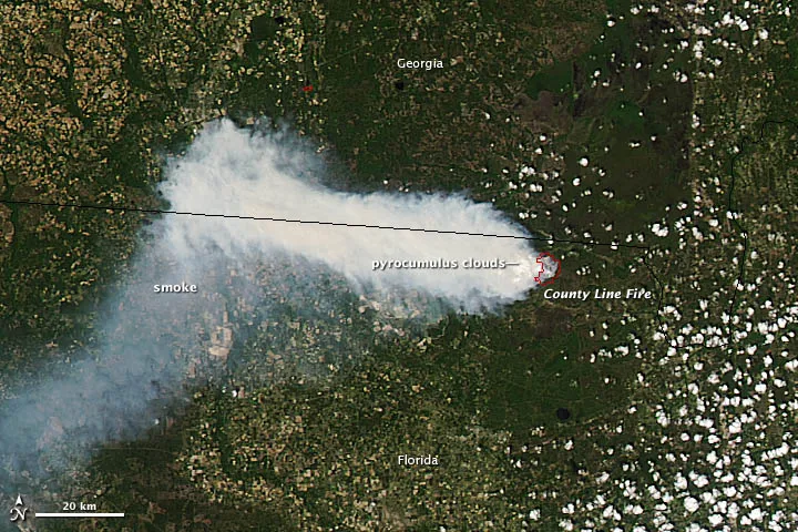
Photo: NASA's Earth Observatory, CC BY 2.0, via Wikimedia Commons
A wildfire's most dangerous hours are its first ones. Federal interagency reviews of major incidents have repeatedly found that detection delays measured in tens of minutes translate directly into acres — and sometimes into evacuations that arrive too late. The technology to catch fires early largely exists. Geostationary satellites scan the continent every few minutes. Towers and ground stations watch forests with cameras and gas sensors. The hard part is not seeing the fire. It is getting what one system sees into the hands of whoever can act on it, fast enough to matter.
Two Watches, Different Clocks
The Nation's orbital sentinels — GOES-16 and GOES-18 hovering in geostationary orbit, plus polar-orbiting assets like those on the Suomi and Joint Polar Satellite Systems — detect thermal anomalies from tens of thousands of miles away. Their advantage is reach: no ridge, canyon, or private timberland escapes their view. Their weakness is temporal resolution and spatial coarseness. A geostationary pixel can cover two square kilometers of the Earth's surface, so a small ignition may not register until it grows, and cloud cover or an unrelated hot rooftop can muddle the signal.
Ground-based networks invert that trade. Camera arrays and low-cost environmental sensors deployed across fire-prone Western states offer fine-grained, near-instantaneous confirmation — but only where someone has installed them. Detection, then, is inherently a fusion problem. The satellite casts the wide net; the ground network verifies, localizes, and refines. Neither alone delivers the fifteen-minute confidence window fire managers want.
Where the Handoff Breaks
Ask anyone who has worked on wildfire data integration what the bottleneck is, and the answer is rarely the sensors themselves. It is the seams between systems.
The fragmentation is institutional as much as technical. Federal agencies, state forestry departments, tribal nations, utility companies, and university research networks each operate detection assets with their own telemetry formats, update intervals, and access rules. A satellite hotspot may be published in one feed, a camera alert in another, and a dispatch system consuming neither until a human stitches them together. Interoperability efforts like the National Interagency Fire Center's shared situational-awareness tools have narrowed the gap, but the pipeline still depends too often on manual correlation.
Latency compounds the problem in less obvious ways. A ground sensor that samples every sixty seconds but transmits on a fifteen-minute cellular batch schedule is, functionally, a fifteen-minute sensor. Similarly, satellite products that undergo ground processing before release can lag real-time conditions by enough to matter during a wind-driven ignition. In detection, the effective latency of a system is the sum of its slowest link — a lesson environmental monitoring has learned repeatedly, from drought networks to air-quality arrays.
What an Integrated Pipeline Requires
Building a genuinely fused detection capability comes down to a handful of engineering and institutional commitments:
- Common timestamps and georeferencing. Data from orbit and from the forest floor is useless together unless both carry accurate, synchronized position and time metadata. That means disciplined clock discipline at ground stations and rigorous geolocation correction on satellite products.
- Low-latency transport. Push-based alerts, edge processing at tower sites, and redundant backhaul — cellular, satellite mesh, or radio — prevent the last mile from becoming the lost mile.
- Machine-readable alert schemas. When a satellite hotspot and a camera plume alert share a common data structure, correlation can happen in software, in seconds, rather than in a dispatch center, in minutes.
- Confidence scoring across sources. Not every thermal anomaly is a fire, and not every camera alert is smoke. Fusion systems that weigh multiple evidence streams — thermal signature, spectral response, ground confirmation — reduce false alarms enough that responders actually trust the alerts.
The Sensing Industry's Role
For the environmental sensing sector, the wildfire detection pipeline represents both a mandate and a market. Utilities in California and the Pacific Northwest are deploying their own sensor and camera networks to protect transmission corridors, and they need instrumentation that speaks the same data language as federal systems. Manufacturers who design for interoperability — open telemetry standards, documented APIs, honest latency specifications — are positioning themselves for a procurement environment where integration capability matters as much as raw accuracy.
The lesson generalizes beyond fire. Every environmental monitoring challenge in the United States, from flood warning in the Mississippi basin to heat-wave mapping in Phoenix, is converging on the same architecture: broad orbital coverage fused with dense ground truth. The agencies and companies that solve the handoff problem for wildfire detection will have built the template for all of it.
The first fifteen minutes of a fire are decided long before the fire starts — in the data pipelines, the metadata standards, and the institutional agreements that determine whether a satellite's faint thermal whisper reaches a fire dispatcher in time. Sensing the planet, one data point at a time, only counts if the data points arrive together.